Map Skills and Zoom Calls for Timberwolves and Pathfinders
This is a set of ideas all around map skills to use while scouting during the 2020 Pandemic. Each zoom meeting idea is laid out below. The set is designed to progress from the most basic ability to read a map, up to reading a topographical map. Each idea is supposed to be the foundation for one meeting. Read them all over, and decide which meetings are appropriate to your group. My group was meeting weekly over zoom, and had scouts that had just joined our pathfinder group, so had never done scout map reading with our group. Thus, we decided to go slowly through the building blocks of map reading with the whole group. It works well when you can allow older scouts to teach younger scouts, and sending groups to work on skills in patrols in zoom breakout rooms can be used for that. Our pathfinders and timberwolves each did several meetings around maps. The pathfinders were able to work with less direction and tackled more complex maps than the younger scouts. However, we were able to figure out ways for both groups to do many of these topics.
Be a Tourist!
Work on general map reading skills. I recommend finding a local tourist attraction to use for your first lesson. This way, you can find maps 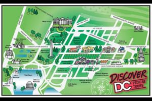 designed for kids, and ones for transit and use one that will most appeal to your group. Our group is near Washington, DC, so we used a map of there. We used a simpler, kid version for our younger scouts. First, we found North, South, East, and West on the map, then I asked each scout questions like, “Which direction is the Capitol building from the Washington Monument?” Every scout had to answer with a direction, and this gave newer scouts a chance to see older scouts answer and to get familiar with the map before their turn. You can move on to discussing terms like north-east and south-west if all goes well. Discussing the compass rose and also if the location you are looking at is north, south, east or west fo your group is also good for scouts to work on directions.
Once your scouts have reviewed directions while you screen shared the map, you can now screen share taking them on an adventure with Google Maps. Put in your location and drop into the map to go for a walk. See if your scouts can figure out which way you should turn to get from one place to another. Go ahead and get lost, it’s okay, no one can get eaten by a bear or hit by a car in on your virtual hike.
Zoo Map and Visit
Visit the local Zoo(or any zoo for that matter)! Use a zoo map to have your scouts work on their map reading skills again this week. Have them plan a route through the zoo, using directions like “Go north past the fountain to the flamingos.” Then use the zoo’s animal cameras to take a peek at the animals. This one takes a bit more skill as the Zoom host who is sharing their screen, but you can also have both leaders taking turns pulling things up. One of you can work on map skills, then switch to the other to pull up the animal videos to watch. This is a great chance to learn both animal facts and review map reading!
Visit an Amusement Park!
Visit an amusement park! You can generally find maps of almost any amusement park, large or small, on-line. Find an amusement park near you, and have your scouts look at the map and plan a route. Amusement parks have lots of landmarks, which makes route planning more interesting. We assigned each of our patrols a different amusement park, and gave them the link to the map for their park. We told them to plan a route through the park that included fun and food. Our GSM told them “Entertain me!” So, scouts competed to plan a day at the park that she would also enjoy. Once the groups had planned their routes, we used Google Maps to follow their route through the parks.
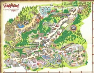 Possible fails: One group planned for us to take a train around the park, but Google Maps wasn’t up for that. Ask scouts to plan foot routes, was a lesson we learned the hard way. We also found that the Google Maps version of one park was several years old, and didn’t have the hotdog stand the kids had chosen to eat at on the most recent park map. That was a disappointment, but an opportunity for making a plan B. Before assigning an amusement park, do check that it is available on Google Maps, not all of them are.
**In our group, the younger scouts did the zoo visit and the older ones did the amusement park. These lessons are fairly similar, so judge which one your group will enjoy most and whether or not both are value-added. We tried to tailor our assigned visits to our groups. We also found that this was a fun way for the kids to explore map reading. They may not be able to visit an amusement park, but joking about making the scoutmaster eat 12 tacos and then get on a roller coaster made them laugh. Watching baby animals at the zoo was also a bright spot after a hard day.
Explore Your City!
See what maps you have available to pull up your own city for scouts to explore. Read the map together and mark where your scout meetings happen. Then look for landmarks like the police and fire stations. Ask scouts,”What route would a fire truck need to take to get to where we usually meet?” Scouts can work on naming streets and stating where to turn, as you mark up the map in screen sharing options. This may even be a chance to work on the Guide Badge requirements! You can once again use Google Maps to have scouts give you directions to follow to get from place to place in your town.
Ride Public Transit!
Does your city (or one nearby) have bus routes, subways or trains you can use? Have your scouts pull up a map of bus routes or subway lines and plan a route. In our group, we gave each patrol a map and a set of place to get to and from. Scouts had to plan which lines to take, and where to get off one train and onto another. Learning to read the maps was easier for some scouts than others, and they worked together to figure out

The Washington, DC Metro lines
answer to questions like “What is the stop that is furthest East on the line?” These questions can also be answered about local bus routes.
Being able to navigate their hometown, or the nearest big city this way is a life skill your scouts need. Learning to read a public transit map, and learning about how a timetable matters for using it, can be tricky. It isn’t the same as the trail maps they may usually use at scouts, so even scouts who have done a lot of map reading with you, may need some help with this.
You may also be able to pull up pictures on Google Maps for scouts to see what a subway station looks like or where a bus stop is. While many scouts have used these services, for ones who have not, just looking at the pictures can help them understand how this works. We also reviewed with our scouts how to purchase tickets, as there were Google Maps pictures of the ticket machines.
Minecraft: The Perfect Intro to Topographical Maps
Minecraft is a great way to bring topographical maps alive. For us, it was also a great chance for our scouts to share this common interest. We warned our scouts in advance we were working on trying to figure out how we could use Minecraft to do some map work to see if any of them had ideas on this topic. One older scout offered to set up a Minecraft server for the troop. So, at our next meeting, he was able to introduce the scouts to the world he had created for them, and several scouts joined the server. We let this older scout do the screen sharing this time and he 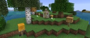 flew above the world, so we could explain how it was like a topographical map. Then he flew lower, so scouts could see how the hills and valleys were actually shaped. The part where each line from above is the same distance apart was a great way to explain how topographical lines are always representing the same amount of vertical change. The same way a Minecraft block is always the same size. Not all of our scouts had used Minecraft, but of the scouts who had, several helped to outline certain topographical lines with a different color block, to help their peers see what we were discussing.
This night, after we had grouped up and discussed the lesson- we left the zoom call open and let a scout screen share so they could watch and play together. The Minecrafting scouts worked hard at covering a small island in TNT and blowing it up. Team work. It was actually a great bonding activity for them. After this call, many of them have met together in Minecraft outside of scouts. For our group, this was a great success that some of our shy scouts found their way into a new way to play together despite the pandemic.
I also thought it would have been interesting to have scouts attempt to sketch on paper the topographical map of a Minecraft world, but when it came down to it, that didn’t appeal to our group. If you try it, let me know how it goes!
Topographical Maps – The Real Deal
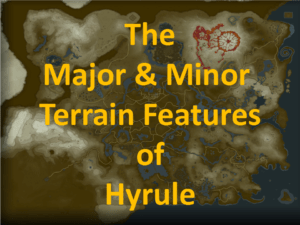 The conclusion of our map reading journey was working with real topographical maps. How much you need to explain what they are looking at, depends on your scouts and if they have ever read a topographical map before. The Akela of the 17th, Garrick Anson has this great set of slides he created to share with scouts to explain what they were looking at. Using the maps of the Nintendo game The Legend of Zelda™: Breath of the Wild, you can demonstrate how different terrain features look on a topographical map.
Many state and national parks have these available for free. You can search the USGS, United State Geological Survey, website for maps to use. https://www.usgs.gov/news/mapping-national-parks-0 We found maps of a local park our scouts have camped at in the past. We then posed a challenge, “Without using the established trails or roads too heavily, find a route from campsite A to campsite B, that won’t be too hard to hike.” Zoom features allowed the scouts to draw on the maps once they had pulled them up on their screens. Each patrol left the leaders for breakout rooms to debate and discuss the possibilities and met back to explain and defend the path each group chose to use. You could also ask your scouts to plan where to camp, to find higher ground, or create a different challenge. 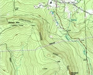
Pointing out that our old knees wouldn’t want to climb a steep incline helped scouts to think about how many elevation lines they were crossing within an inch on the map. We did allow scouts to walk beside of a river bank, where it was nice and flat, and also debated the advantages of going over a hill vs around it. Overall, it would have been even better if we could have gone out to the site and actually attempted hiking the routes they planned, but this was a great planning activity anyway.
If you use a local trail, you can challenge scouts to take their maps along and see what they think of the elevation changes on a trail and report back.
Summing It Up
Overall, I think this was the best set of map sessions we’ve ever done. Using the features in Zoom allowed us to tackle map reading differently than usual, which was nice. Starting with the most basic review of directions and getting gradually more complicated as we went allowed for even the scouts who hadn’t done much map reading to be successful. Reading a wide variety of maps also made it more interesting to scouts who had done other forms of map reading in the past. It was also interesting to be able to pretend we could leave the house and go to almost anywhere. If your group is more creative, you can look up maps and Google Maps info for almost anywhere on earth and take a virtual field trip. Create drama by skirting an active volcano, or charting a course between islands.
We did this set of lessons over the course of a few months, and took a break a few times to do other topics in between, to keep things fresh. But you and your group can figure out what is fun for you right now. Ask your scouts where they want to go, and give it a shot! Virtual field trips make anything possible.